Should every farmer have a satellite in their fleet?
PRECISION FARMING – From sowing to harvest.
Precision farming represents an innovative approach in modern agriculture that aims to increase yields and resource efficiency. Pioneering farmers were very early adopters of new technologies to carry out tasks such as fertilising and sowing more precisely. The development began in the early 1980s with the introduction of GPS technology in agricultural machinery. This enabled more precise control of field work. One of the main benefits was the avoidance of waste and overlapping work and the associated savings in products and operating resources. Since the early days, there has been a veritable hype of innovation in agricultural technologies in order to realise further efficiencies. Working widths and driving speeds have been increased, spreading patterns and grain placement have been optimised. Knowledge of the conditions under which application rates and timing can be optimised has been built up over many years of trials.
UTILISE THE POTENTIAL OF DIGITAL TECHNOLOGIES!
” Connected farming brings the successes of the pioneers to our farm as a benefit.”
Today, precision farming methods are widely supported. Virtually every new machine and every new tractor supports (where appropriate) the functions known as GPS-assisted steering control, section control (SC), row-end shut-off and variable rate application (VRA). If a modern fleet of vehicles is available on the farm or can be hired out, why leave the potential untapped?
Practical application often fails because the pioneers’ path is too long, too complex or impractical. With the possibilities of digitalisation, we can overcome these hurdles, make pioneering expertise widely available, satisfy the information hunger of these methods more easily and quickly and make the benefits of precision farming available in the production of food – with the best possible yield, in high quality, sustainably and environmentally friendly.
PRECISION SEEDING!
“Up to 12% more yield with the help of variable maize sowing”
As reported in SAATBAU INFORM #01/2023, FARMDOK and SAATBAU LINZ are offering a digital tool to further increase yield security in maize cultivation in conjunction with climate-smart maize varieties. The method is based on reducing the sowing rate in zones with lower yield potential, while increasing it in zones with higher yield potential. In dry years with increased plant stress, this avoids competition for nutrients and water in weaker zones and supports good cob development. In better zones, the potential is better utilised. The average sowing density is not changed with this method. In stressful years, an additional yield of 3-12% can be expected, depending on the area (dry/wetland) and the cultivation method (organic/conventional). A higher maize price can also be expected in these years. In good years with sufficient water and nutrient supply, no significant additional yields are to be expected. However, variable sowing has not shown any negative effects either. Long-term trials carried out by SAATBAU LINZ in cooperation with the Innovation Farm in Wieselburg have shown that adjusting the sowing rate to the yield potential of the soil in conjunction with the most suitable variety with regard to climate change provides risk protection and corresponding additional yields.
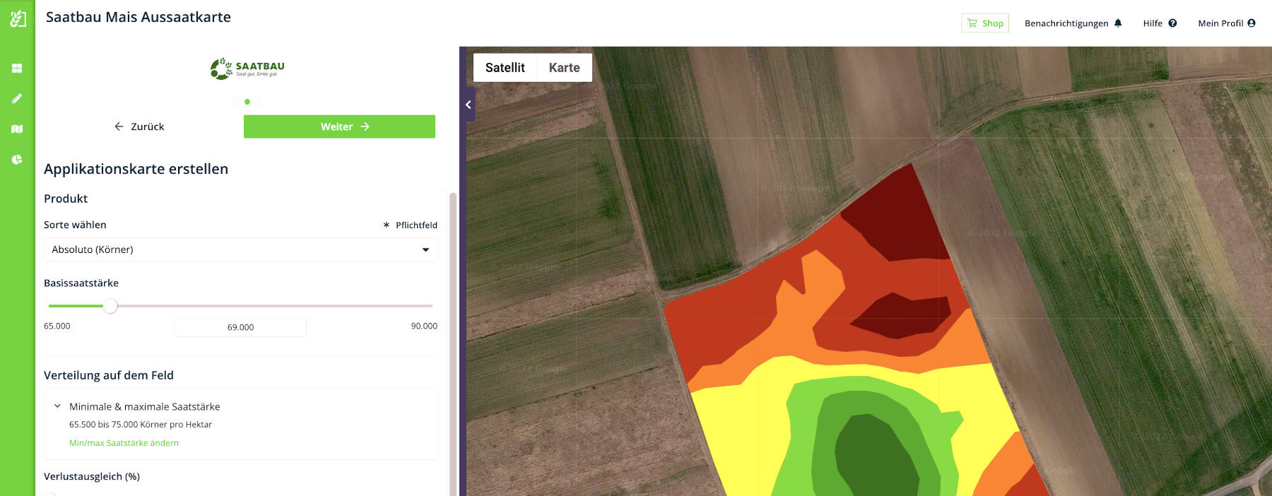
The geo-contours of the fields are required to create application maps. In Farmdok, there are three options for this: importing the fields from eAMA from the last submitted multiple application, manual creation with a click in the centre of the field in Farmdok or importing external data in the formats Shape, KML, ISOXML and many more. In principle, there is nothing to be said against manual creation or eAMA import for the purpose of creating application maps for variable maize sowing. However, it should be noted that this geodata is predominantly not created by precise surveying, but by visual marking on a map or orthophoto. Depending on the seed drill, individual sowing coulters, a partial width or the entire width are switched off if the seed drill protrudes beyond the geo-contour. If no precise contours are available or the origin is unknown, it is recommended to work the outermost track without VRA to prevent this.
A unique feature of Farmdok is that application maps do not have to be created for each field individually, but can be created for all fields of a crop or variety at once. This is possible because the technology developed by Farmdok enables an absolute assessment of yield potential, not just a relative assessment of where there is more or less biomass in a field. This is also the reason why the number of zones in Farmdok is not fixed. Depending on which fields are selected, there are zones with higher and lower yields. Classification is based on a plant growth model using satellite and weather data from the last 5 years.
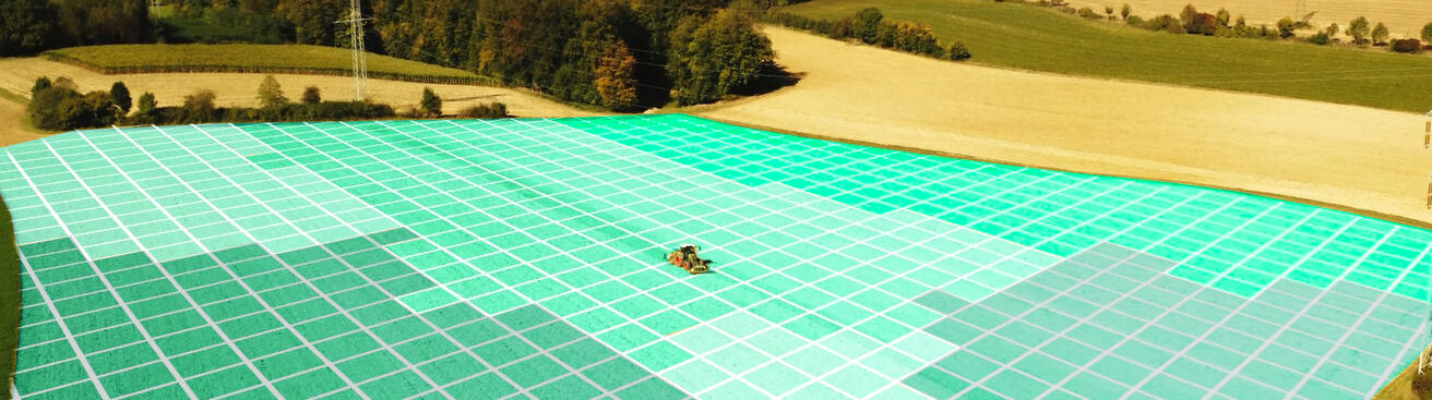
Based on the selected maize variety, an average seed rate is automatically recommended for the fields. This basic seed rate is varied depending on the yield potential of the zones. The colouring of the zones from deep green to dark brown shows the differentiation between yield potential and seed rate. Ultimately, however, it is the farmer who decides how the seed is sown in the field. Both the basic seed rate and the upper and lower limit values can be changed at the farmer’s discretion. Loss compensation is a simple way of taking into account special influences such as the loss of plants, e.g. due to mechanical weed control, seedbed conditions or animal damage.
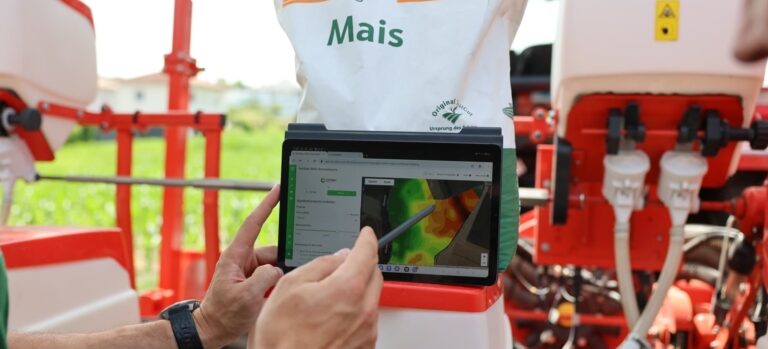
Image credits: Saatbau Linz
Once the prescription map has been created, it is transferred to the ISOBUS terminal. For this purpose, the prescription map can be exported from Farmdok in the ISOXML TASKDATA or Shape formats in the various machine manufacturer versions. It is transferred to the terminal using a USB memory stick. Make sure that application maps in ISOXML TASKDATA format have the exact file name “TASKDATA.XML” and find out about the necessary folder structure on the USB stick. Otherwise, problems may occur when reading the prescription map on the ISOBUS display. Alternatively, the prescription map can also be transferred wirelessly to the tractor.
To summarise, it has never been so easy to create an optimum prescription map for variable maize sowing. If fields with geodata are available, the selection of the variety is the only necessary parameter. Soil samples, weather and climate data as well as field experience are useful information, but are no longer essential for the practical implementation of precision farming.
RECORD AUTOMATICALLY!
“Close the data loop with the ISOBUS terminal“
State-of-the-art ISOBUS devices are not only able to control the application rate of seed, fertiliser and crop protection during application. They can also record and log the job information including machine and implement parameters in geolocalised form. The recorded information is saved in ISOXML TASKDATA format. The advantage of this data format is that the content is standardised by the very comprehensive ISO11783 standard. Recordings from machines that support this standard can be read and processed by other software systems.
New: Farmdok supports the import of recordings in ISOXML TASKDATA format. ISOBUS terminals with an activation of the TC-BAS (Task Controller Basic) module are now able to automate the documentation of field work. The records can be imported into Farmdok by uploading the TASKDATA data. For Steyr, Case IH and New Holland tractors, a direct import of records from S-Fleet, AFS Connect or PLM Connect is also supported. Data transfer via USB stick is no longer necessary.
From crop management decisions to the avoidance of incorrect processing in the field. From the fulfilment of legal recording obligations to cost accounting. The basis for every purpose is the recording of field work. This closes the data cycle and creates a stable foundation of information for future challenges and decisions.